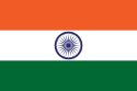
INDIA
India, officially the Republic of India ( Bhārat Gaṇarājya), is a country in South Asia. It is the seventh-largest country by area, the second-most populous country, and the most populous democracy in the world. Bounded by the Indian Ocean on the south, the Arabian Sea on the southwest, and the Bay of Bengal on the southeast, it shares land borders with Pakistan to the west; China, Nepal, and Bhutan to the north; and Bangladesh and Myanmar to the east. In the Indian Ocean, India is in the vicinity of Sri Lanka and the Maldives; its Andaman and Nicobar Islands share a maritime border with Thailand, Myanmar and Indonesia.
India has been a federal republic since 1950, governed in a democratic parliamentary system. It is a pluralistic, multilingual and multi-ethnic society. India's population grew from 361 million in 1951 to 1.211 billion in 2011. During the same time, its nominal per capita income increased from US$64 annually to US$1,498, and its literacy rate from 16.6% to 74%. From being a comparatively destitute country in 1951, India has become a fast-growing major economy and a hub for information technology services, with an expanding middle class. It has a space programme which includes several planned or completed extraterrestrial missions. Indian movies, music, and spiritual teachings play an increasing role in global culture. India has substantially reduced its rate of poverty, though at the cost of increasing economic inequality. India is a nuclear-weapon state, which ranks high in military expenditure. It has disputes over Kashmir with its neighbours, Pakistan and China, unresolved since the mid-20th century. Among the socio-economic challenges India faces are gender inequality, child malnutrition, and rising levels of air pollution. India's land is megadiverse, with four biodiversity hotspots. Its forest cover comprises 21.7% of its area. India's wildlife, which has traditionally been viewed with tolerance in India's culture, is supported among these forests, and elsewhere, in protected habitats
.
Republic of India
Bhārat Gaṇarājya
|
|---|
 Flag  State emblem |
Motto: "Satyameva Jayate" (Sanskrit)
"Truth Alone Triumphs" |
Anthem: "Jana Gana Mana"
"Thou Art the Ruler of the Minds of All People"
The saving of all people waits in thy hand,
MENU
0:35
|
National song
"Vande Mataram" (Sanskrit)
"I Bow to Thee, Mother" |
| Capital | New Delhi
 28°36′50″N 77°12′30″E 28°36′50″N 77°12′30″E |
|---|
| Largest city | - Mumbai (city proper)
- Delhi (metropolitan area)
|
|---|
| Official languages | |
|---|
| Recognised national languages | None |
|---|
| Recognised regional languages |
State level and Eighth Schedule |
|---|
| Native languages | 447 languages |
|---|
| Religion (2011) | - 79.8% Hinduism
- 14.2% Islam
- 2.3% Christianity
- 1.7% Sikhism
- 0.7% Buddhism
- 0.4% Jainism
- 0.23% Unaffiliated
- 0.65% Others
|
|---|
| Demonym(s) | Indian |
|---|
| Membership | - UN
- Commonwealth of Nations
- WTO
- BRICS
- SAARC
- SCO
- G4 nations
- Group of Five
- G8+5
- G20
|
|---|
| Government | Federal parliamentary constitutional republic |
|---|
|
• President | Ram Nath Kovind |
|---|
• Vice President | Venkaiah Naidu |
|---|
• Prime Minister | Narendra Modi |
|---|
• Chief Justice | N. V. Ramana |
|---|
• Lok Sabha Speaker | Om Birla |
|---|
| Legislature | Parliament |
|---|
• Upper house | Rajya Sabha |
|---|
• Lower house | Lok Sabha |
|---|
|
|
• Dominion | 15 August 1947 |
|---|
• Republic | 26 January 1950 |
|---|
|
• Total | 3,287,263 km2 (1,269,219 sq mi)(7th) |
|---|
• Water (%) | 9.6 |
|---|
|
• 2018 estimate |  1,352,642,280 (2nd) 1,352,642,280 (2nd) |
|---|
• 2011 census | 1,210,854,977 (2nd) |
|---|
• Density | 413.3/km2 (1,070.4/sq mi) (19th) |
|---|
Etymology
According to the Oxford English Dictionary (third edition 2009), the name "India" is derived from the Classical Latin India, a reference to South Asia and an uncertain region to its east; and in turn derived successively from: Hellenistic Greek India; ancient Greek Indos; Old Persian Hindush, an eastern province of the Achaemenid empire; and ultimately its cognate, the Sanskrit Sindhu, or "river," specifically the Indus River and, by implication, its well-settled southern basin. The ancient Greeks referred to the Indians as Indoi which translates as "The people of the Indus".
The term Bharat, mentioned in both Indian epic poetry and the Constitution of India, is used in its variations by many Indian languages. A modern rendering of the historical name Bharatavarsha, which applied originally to northern India Bharat gained increased currency from the mid-19th century as a native name for India.
Hindustan is a Middle Persian name for India, introduced during the Mughal Empire and used widely since. Its meaning has varied, referring to a region encompassing present-day northern India and Pakistan or to India in its near entirety.
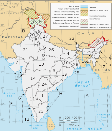
Administrative divisions
India is a federal union comprising 28 states and 8 union territories. All states, as well as the union territories of Jammu and Kashmir, Puducherry and the National Capital Territory of Delhi, have elected legislatures and governments following the Westminster system of governance. The remaining five union territories are directly ruled by the central government through appointed administrators. In 1956, under the States Reorganisation Act, states were reorganised on a linguistic basis. There are over a quarter of a million local government bodies at city, town, block, district and village levels.
STATES
A clickable map of the 28 states and 8 union territories of India
- Andhra Pradesh
- Arunachal Pradesh
- Assam
- Bihar
- Chhattisgarh
- Goa
- Gujarat
- Haryana
- Himachal Pradesh
- Jharkhand
- Karnataka
- Kerala
- Madhya Pradesh
- Maharashtra
- Manipur
- Meghalaya
- Mizoram
- Nagaland
- Odisha
- Punjab
- Rajasthan
- Sikkim
- Tamil Nadu
- Telangana
- Tripura
- Uttar Pradesh
- Uttarakhand
- West Bengal
UNION TERRITORIES
- Andaman and Nicobar Islands
- Chandigarh
- Dadra and Nagar Haveli and Daman and Diu
- Jammu and Kashmir
- Ladakh
- Lakshadweep
- National Capital Territory of Delhi
- Puducherry


Comments
Post a Comment